Vertix Robotics
Transforming Satellite and Aerial Imagery into High‑Quality AI‑Ready Geospatial Data

Remote Sensing

Accelerating AI Development in Earth Observation with Scalable Remote Sensing Data Annotation

Unlocking the full potential of AI and Big Data in Earth Observation requires high-quality, large-scale labelled datasets. Vertix Robotics offers an efficient and cost-effective solution for annotating airborne and satellite imagery, enabling faster and more accurate dataset creation. Vertix empowers researchers, developers, and organisations to train and deploy AI algorithms with greater confidence and reliability by streamlining the annotation process. Whether for environmental monitoring, urban planning, or disaster response, Vertix ensures your remote sensing data is ready for advanced AI applications, transforming raw imagery into actionable insights at scale.

Edge AI Revolutionizing Multiple Industries

Edge AI Revolutionizes: Six Industries, One Geospatial Backbone

Edge AI and geospatial data annotation are transforming how we see, map, and manage the physical world. From autonomous mobility and defense intelligence to disaster response, smart cities, industry, and agriculture, AI‑powered labelling of satellite, drone, aerial, and multispectral imagery is enabling real‑time, high‑precision decision‑making across six critical domains.

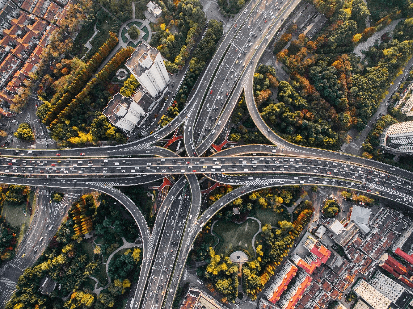
Transportation & Logistics

  • Creating HD maps from satellite and drone imagery for autonomous vehicles
  • Annotating road networks and traffic signs to enable smart mobility systems
  • Oriented bounding box annotation for vehicle direction and trajectory detection
  • Leveraging AI‑driven annotation for real‑time traffic monitoring and analytics
  • Lane and intersection detection using UAV imagery for AV navigation
  • Supporting V2X systems with precise, up‑to‑date geospatial data

Defense & Intelligence

  • Monitoring military activity with high‑resolution satellite image annotation
  • Identifying threats and assets in high‑GSD aerial imagery
  • Tracking object movement in conflicted zones using AI‑based detection
  • Secure, air‑gapped data labelling pipelines for classified missions
  • Oriented object detection to support tactical decision‑making at the edge
  • Annotating night‑time and infrared data for persistent surveillance

Disaster Management

  • AI‑powered damage detection in the aftermath of natural disasters
  • Flood zone mapping using annotated satellite and aerial imagery
  • Tracking evacuation routes with UAV‑based annotations
  • Fire spread prediction leveraging annotated thermal and infrared data
  • Pre‑ and post‑disaster change detection with geospatial AI
  • Supporting humanitarian aid through real‑time geospatial labelling

Industrial & Environmental Monitoring

  • Detecting deforestation with high‑resolution labelled satellite imagery
  • Annotating satellite data to monitor water bodies, floods, and shoreline changes
  • Tracking air and water pollution via remote sensing and AI labelling
  • Climate change impact analysis using annotated geospatial datasets
  • Identifying and monitoring protected habitats with UAV‑captured data
  • AI‑assisted wildfire mapping using thermal imagery annotation
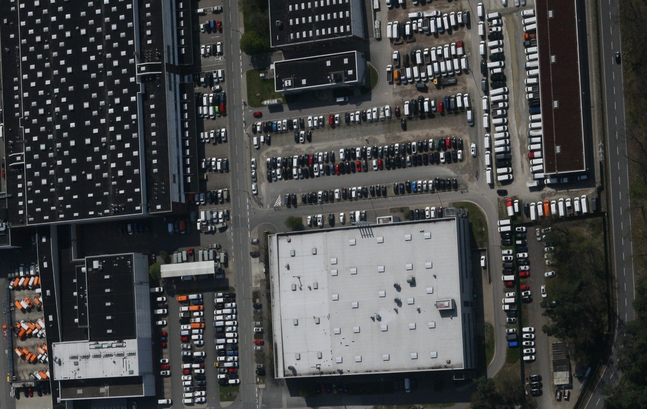
Smart City

  • Mapping urban expansion with annotated satellite imagery
  • Using remote sensing labels to optimise public infrastructure planning
  • AI in smart city planning, with annotated data as the core backbone
  • Building detection and zoning through aerial annotation tools
  • High‑resolution object tracking for traffic flow and congestion analysis
  • Monitoring green spaces in urban environments via AI labelling

Agriculture

  • Enhancing crop yield forecasting with remote sensing annotation
  • AI‑powered weed and pest detection across farmlands
  • Monitoring irrigation patterns using aerial image annotation
  • Annotated multispectral imagery for soil health and nutrient analysis
  • Revolutionising agricultural mapping with UAV and satellite data
  • Data‑driven farm management through AI and geospatial labelling

High‑Quality Annotation for AI‑Driven Earth Observation

Unlocking the full potential of AI and Big Data in Earth Observation requires high-quality, large-scale labelled datasets. Vertix Robotics offers an efficient and cost-effective solution for annotating airborne and satellite imagery, enabling faster and more accurate dataset creation. Vertix empowers researchers, developers, and organisations to train and deploy AI algorithms with greater confidence and reliability by streamlining the annotation process. Whether for environmental monitoring, urban planning, or disaster response, Vertix ensures your remote sensing data is ready for advanced AI applications, transforming raw imagery into actionable insights at scale.

Why Vertix Robotics?

Advanced Remote Sensing & Geospatial AI Labelling

Vertix Robotics combines domain expertise with cutting-edge tools to deliver precise, scalable, and secure labeling services specifically designed for Earth Observation.

With a deep understanding of the unique challenges in remote sensing data annotation, we enable organizations to handle complex and sensitive projects with confidence. Our experienced team leverages localized infrastructure and supports diverse sensor types—including optical, multispectral, hyperspectral, SAR, DSM, thermal, and infrared—prioritizing quality, consistency, and data security to accelerate your AI development.

Multi-Sensor Expertise

Support for Optical, Multispectral, SAR, DSM, and Thermal data annotation.

Secure Infrastructure

Localized pipelines ensuring the highest standards of data privacy and security.

Domain-Specific Tools

Cutting-edge tools tailored for the unique challenges of geospatial imagery.

Scalable Precision

High-quality, consistent labelling designed to scale with your AI development needs.

Oriented Bounding Box

As one of the unique features of our AI-powered annotation tool, we offer oriented bounding box annotation, allowing you to capture not only the position but also the heading direction of an object. This is particularly valuable for annotating vehicles, airplanes, and ships, where the head and tail have distinct appearances. Unlike standard bounding boxes, oriented boxes can more accurately represent rotated or angled objects, significantly improving detection and tracking performance. This added information is especially beneficial in object tracking and movement prediction tasks in dynamic environments such as urban traffic monitoring, maritime surveillance, and aerial reconnaissance. With this advanced capability, you can enhance your dataset’s precision and enable more intelligent AI behavior.

Why Vertix Robotics?

Precision Annotation for Next‑Generation AI

At Vertix Robotics, we go beyond basic annotation by providing advanced data labeling capabilities designed for modern AI perception systems.

Our platform supports advanced techniques such as oriented bounding box annotation, enabling accurate representation of object direction and geometry. This level of precision is essential for tasks including object tracking, trajectory prediction, and behavior analysis. Combined with support for diverse sensor types and a secure, scalable infrastructure, Vertix Robotics ensures that your AI models are trained using high‑quality, context‑aware datasets. Whether your projects focus on smart transportation, defense applications, or environmental monitoring, our team delivers the tools, expertise, and reliability required to power next‑generation AI solutions.

Oriented Bounding Boxes

Advanced annotation enabling precise direction and geometry representation for complex objects.

Trajectory & Behavior Insights

High‑precision labels that support object tracking, trajectory prediction, and behavioral analysis.

Multi‑Sensor Data Support

Annotation pipelines compatible with diverse sensors used in robotics, geospatial, and AI systems.

Secure & Scalable Infrastructure

Robust data pipelines designed for large‑scale projects with strict security and reliability.

Video Tracking

Single- and multi-object tracking annotation is inherently difficult and time-consuming. The challenge intensifies when dealing with tiny objects in airborne and satellite imagery, where complex backgrounds, low resolution, shadows, and occlusions make accurate tracking extremely demanding. Recognizing this, Vertix has developed an advanced AI-powered annotation tool designed specifically to handle the precise tracking of very small objects—such as vehicles—even when Ground Sampling Distance (GSD) is significantly high. The system supports both orthorectified and registered data, as well as raw imagery. With robust algorithms and intuitive interfaces, our tool simplifies complex tracking tasks while enhancing annotation accuracy, speed, and efficiency.

Why Vertix Robotics?

Precision Remote Sensing Annotation for AI Tracking

Vertix Robotics tackles some of the most challenging problems in remote sensing annotation, enabling accurate labeling and tracking even in difficult imaging conditions.

Vertix Robotics stands out by addressing complex challenges such as tracking tiny, fast‑moving objects in low‑resolution and high‑GSD imagery. Our proprietary AI‑powered tools, developed within the Vertix Robotics framework, are designed for both precision and efficiency—allowing teams to annotate large datasets at scale without sacrificing quality. Whether working with raw satellite imagery or orthorectified geospatial data, Vertix ensures a streamlined, secure, and high‑performance annotation pipeline. With a strong commitment to innovation and reliability, we help organizations generate the high‑quality training data required to build robust, real‑world AI tracking systems.

Tiny Object Tracking

Specialized annotation methods for detecting and tracking small, fast‑moving targets in satellite imagery.

Low‑Resolution & High‑GSD Expertise

Optimized workflows designed for challenging imagery conditions and large ground sampling distances.

AI‑Powered Annotation Tools

Proprietary Vertix tools that accelerate labeling while maintaining high precision and consistency.

Secure & Scalable Pipeline

Robust infrastructure supporting both raw and orthorectified data for large‑scale AI training datasets.

HD Mapping

HD maps are essential for a wide range of applications, including autonomous driving, urban planning, and infrastructure management. Until recently, these maps were created exclusively by expensive mobile mapping vehicles. However, with the dedicated and innovative annotation tool developed by Vertix, HD mapping projects can now efficiently achieve their primary objectives. This advanced tool streamlines the annotation process, reduces costs, and improves accuracy, enabling faster deployment of high-definition maps across diverse environments and use cases.

Why Vertix Robotics?

Precision HD Mapping Annotation for Geospatial Data

Vertix Robotics brings precision, scalability, and cost‑efficiency to HD mapping through advanced annotation technologies.

Vertix Robotics brings precision, scalability, and cost‑efficiency to HD mapping through its cutting-edge annotation technologies. By leveraging tools like the one developed by Nazru, Vertix enables organizations to generate detailed, accurate HD maps without relying solely on expensive mobile mapping vehicles. Our experienced team and secure infrastructure ensure high-quality annotations across large datasets—whether for autonomous navigation, smart cities, or infrastructure analytics. With Vertix, you get a trusted partner committed to accelerating your mapping goals through innovative, AI-powered solutions tailored to the complexities of geospatial data.

Cost‑Efficient HD Mapping

Create detailed HD maps through advanced annotation workflows without relying on expensive mobile mapping vehicles.

AI‑Powered Annotation Tools

Leverage innovative AI‑assisted technologies, including tools developed by Nazru, to improve speed and accuracy.

Scalable Data Processing

Efficiently process and annotate large geospatial datasets with scalable pipelines and optimized workflows.

Secure & Reliable Infrastructure

Ensure consistent high‑quality annotations with a secure infrastructure and an experienced annotation team.

AI-Powered Remote Sensing Annotation Solutions by Vertix Robotics

Vertix Robotics Remote Sensing Services Vertix Robotics delivers high-quality, AI-powered annotation solutions for remote sensing applications using drone, aerial, and satellite imagery. Supporting formats like optical, SAR, DSM, and thermal, Vertix handles tasks such as object tracking, semantic segmentation, and HD mapping with precision. Our scalable infrastructure, advanced tools, and expert team ensure fast, secure, and consistent labeling—empowering organizations to build accurate, large-scale datasets essential for Earth Observation and AI development.

Why Vertix Robotics?

Scalable Remote Sensing Annotation for Earth Observation

Vertix Robotics provides scalable, accurate, and secure data annotation services designed for modern remote sensing and AI development.

Vertix Robotics stands at the forefront of remote sensing innovation by providing scalable, accurate, and secure data annotation services. Our deep expertise in handling complex geospatial formats—ranging from satellite to drone imagery—ensures that your datasets are prepared to meet the demands of advanced AI development. With robust tools, flexible infrastructure, and a dedicated team, Vertix helps you transform raw imagery into actionable insights, accelerating research, operations, and decision‑making across Earth Observation domains.

Satellite & Drone Imagery Expertise

Deep experience working with complex geospatial data formats from satellite and aerial platforms.

AI‑Ready Data Annotation

Prepare high‑quality datasets optimized for advanced AI, machine learning, and remote sensing models.

Scalable Annotation Infrastructure

Flexible systems designed to process and annotate large Earth Observation datasets efficiently.

Actionable Geospatial Insights

Transform raw imagery into structured data that accelerates research, analytics, and operational decisions.

What is remote sensing data annotation?

Remote sensing data annotation is the process of labeling satellite, aerial, and drone imagery so that AI and analytics systems can reliably interpret Earth Observation data. It includes tasks such as object detection, pixelwise segmentation, change detection, HD mapping, and tracking objects over time across optical, multispectral, hyperspectral, SAR, DSM, thermal, and infrared data.

Why are high-quality labels essential for Earth Observation AI?

High-quality, consistent labels are critical because they directly determine how well AI models understand geospatial scenes. Precise annotation reduces noise in training datasets, improves model accuracy and generalization, and enables robust performance in applications like environmental monitoring, urban analytics, disaster response, and infrastructure management.

What types of remote sensing annotation services does Vertix Robotics provide?

Vertix Robotics supports a wide range of annotation tasks for remote sensing, including pixelwise semantic segmentation, polygon and instance segmentation, oriented and horizontal bounding boxes, HD mapping layers, object tracking in video and time series, change detection, land-use and land-cover classification, and tiny-object labeling in high-GSD imagery.

How does Vertix Robotics handle different sensor modalities such as optical, SAR, and thermal?

Vertix Robotics is experienced with diverse sensor types, including optical, multispectral, hyperspectral, SAR, DSM, thermal, and infrared imagery. Our workflows and tools are tuned for the specific characteristics of each modality—such as speckle in SAR or low-light thermal imagery—so that labels remain accurate, consistent, and scientifically meaningful across heterogeneous datasets.

How does remote sensing annotation support applications like environmental monitoring and urban planning?

Accurate annotation transforms raw imagery into structured geospatial information. For environmental monitoring, labels can describe deforestation, water bodies, habitats, or pollution patterns. For urban planning, annotations capture buildings, roads, land use, infrastructure, and green spaces. These labeled datasets power AI models that detect trends, quantify change, and support better data-driven decisions.

What is special about oriented bounding box annotation in remote sensing?

Oriented bounding box annotation encodes not only the position but also the rotation and heading of objects such as vehicles, ships, and aircraft. This is particularly important in overhead imagery where objects are rarely axis-aligned. Oriented boxes provide more accurate geometry, improve detection quality for rotated targets, and are crucial for trajectory estimation and behavior analysis in dynamic scenes.

How does Vertix Robotics address tiny object tracking in high-GSD aerial and satellite imagery?

Tracking very small objects in high-GSD imagery is challenging due to low resolution, cluttered backgrounds, shadows, and occlusions. Vertix Robotics uses AI-assisted annotation tools specifically designed for tiny-object tracking, enabling annotators to follow vehicles and other targets frame by frame, even when they occupy only a few pixels. This results in higher-quality trajectory data for downstream AI models.

How does Vertix Robotics ensure scalability and cost-efficiency for large Earth Observation projects?

Vertix Robotics combines AI-powered pre-annotation, optimized workflows, and a scalable, secure infrastructure to handle very large volumes of satellite and airborne imagery. By automating repetitive tasks and focusing human effort on quality-critical steps, we reduce turnaround time and cost while maintaining strict accuracy and consistency standards across massive datasets.

How does Vertix Robotics handle data security and sensitivity in remote sensing projects?

Data security is a core part of our remote sensing services. Vertix Robotics operates on secure, access-controlled infrastructure, supports localization and region-specific deployment when required, and follows strict confidentiality and compliance practices. This allows us to safely process sensitive geospatial datasets, including defense, critical infrastructure, and disaster-response imagery.

Why should organizations choose Vertix Robotics for remote sensing annotation?

Organizations choose Vertix Robotics because we combine deep domain expertise in Earth Observation with advanced AI-powered annotation tools, experienced teams, and robust QA processes. From HD mapping and environmental monitoring to smart city and defense applications, Vertix delivers precise, scalable, and secure labeling pipelines that turn raw remote sensing imagery into AI-ready, actionable geospatial datasets.